
AIM 1−1−17. Global Positioning System (GPS)
The Global Positioning System is a space-based radio navigation system used to determine precise position anywhere in the world. The 24 satellite constellation is designed to ensure at least five satellites are always visible to a user worldwide. A minimum of four satellites is necessary for receivers to establish an accurate three−dimensional position.
There are two types of GPS systems certified for use in aircraft. The AIM refers to them without clearly explaining what they are. Equipment certified under TSO−C145() or TSO−C146() are referred to as augmented GPS, WAAS-capable GPS, or WAAS. Prior to WAAS availability, GPS systems were certified under TSO-C129() or TSO-C196(). They are referred to as un-augmented or non-WAAS systems. When the FAA uses the term GPS/WAAS in the aim they are referring to both un-augmented systems (GPS) and WAAS-enabled systems (WAAS).
Integrated units like the Garmin 400W/500W series are certified under TSO-C146a. Devices that feed GPS data to ADS-B devices are certified under TSO-C145a. For example, the GDL 90 includes a TSO-C145a WAAS GPS sensor that can feed other devices with position information.
Receiver Autonomous Integrity Monitoring (RAIM)
RAIM is the capability of a GPS receiver to perform integrity monitoring on itself by ensuring available satellite signals meet the integrity requirements for a given phase of flight. RAIM requires a minimum of 5 satellites, or 4 satellites and barometric altimeter input (baro−aiding), to detect an integrity anomaly. Baro−aiding is a method of augmenting the GPS integrity solution by using a non-satellite input source in lieu of the fifth satellite. (All modern GPS receivers have baro-aiding.)
The RAIM algorithm can be improve upon by using the aircraft pressure altitude, as the vertical position, although less accurate than the lateral position, can substitute for one of the satellites. This is called Baro Aiding and probably all IFR GPS installations use this. With Baro Aiding, only four satellites are needed to determine a value of RAIM. John D Collins
Baro-aiding is a type of GPS integrity augmentation that basically allows your GPS to use your static system to provide a vertical reference and reduce the number of satellites required. GPS units that have baro-aiding are much less likely to experience outages. Some units require manual entry of the altimeter setting for baro-aiding. If your GPS unit prompts you for current altimeter setting, be sure to enter it each time when relying on baro-aiding.
The units below require baro-aiding as part of their installation, and therefore if your GPS was installed properly you have baro-aiding.
GPS 155, GPS 155XL, GPS 165, GNC 300, GNC 300XL, GPS 400, GNC 420, GNS 430, GPS 500, GNS 530, G1000 (pre-TSO C146a versions), Apollo GX50, Apollo GX60, Apollo GX65
AOPA
You can check RAIM graphs at the FAA site sapt.faa.gov. Here’s one for non-precision approaches using a receiver with baro-aiding.

Wide Area Augmentation System (WAAS)
The WAAS is made up of an integrity reference monitoring network, processing facilities, geostationary satellites, and control facilities. Wide area reference stations and integrity monitors are widely dispersed data collection sites that contain GPS/WAAS ranging receivers that monitor all signals from the GPS, as well as the WAAS geostationary satellites. The reference stations collect measurements from the GPS and WAAS satellites so that differential corrections, ionospheric delay information, GPS/WAAS accuracy, WAAS network time, GPS time, and UTC can be determined. The wide area reference station and integrity monitor data are forwarded to the central data processing sites. These sites process the data in order to determine differential corrections, ionospheric delay information, and GPS/WAAS accuracy, as well as verify residual error bounds for each monitored satellite. The central data processing sites also generate navigation messages for the geostationary satellites and WAAS messages. This information is modulated on the GPS-like signal and broadcast to the users from geostationary satellites. (WAAS Test Team)

If for some reason, the WAAS signal can’t be received, the WAAS GPS defaults to a non-WAAS mode of operation and RAIM is used.
In general, inside the WAAS area of coverage, the WAAS integrity data is used and RAIM is not. That is why one does not need to check RAIM availability for a flight with a WAAS receiver, unless they are flying outside the service volume of WAAS or there is a WAAS system wide outage via a NOTAM. John D Collins
IFR Use of GPS
Handheld GPS
VFR GPS panel mount receivers and hand−held units have no RAIM alerting capability. This prevents the pilot from being alerted to the loss of the required number of satellites in view, or the detection of a position error. Portable, wireless, ADS-B and WAAS GPS receivers like Stratus and Garmin GDL 39 do have WAAS but are not certified for IFR flight. Therefore:
Visual flight rules (VFR) and hand−held GPS systems are not authorized for IFR navigation, instrument approaches, or as a principal instrument flight reference.
Non-WAAS
Aircraft using [un-augmented GPS] for navigation under IFR must be equipped with an alternate approved and operational means of navigation suitable for navigating the proposed route of flight. (Examples of alternate navigation equipment include VOR or DME/DME/IRU capability). Active monitoring of alternative navigation equipment is not required when RAIM is available for integrity monitoring. Active monitoring of an alternate means of navigation is required when the GPS RAIM capability is lost.
The point of the special rules using GPS as an alternate has to do with the fact that non-WAAS GPS is supplementary navigation. That means, you must be equipped with other navigation systems suitable for the route being flown that may be used in the event that GPS is not available. This includes considerations where you plan to use GPS in lieu of other required equipment such as a DME or ADF. John D Collins
GPS with WAAS
1−1−18 9. Unlike TSO−C129 avionics, which were certified as a supplement to other means of navigation, WAAS avionics are evaluated without reliance on other navigation systems. As such, installation of WAAS avionics does not require the aircraft to have other equipment appropriate to the route to be flown.
In the case of a WAAS GPS, it meets the requirements of FAR 91.205 without any other equipment being installed, so there are no restrictions on using suitable approaches with GPS. However, the WAAS integrity may or may not always be sufficient to support LP, LPV, or LNAV/VNAV vertical guidance. So the planning must be based on using the LNAV minimums, for which the standard alternate weather is 800-2. John D Collins
Preflight
1−1−17. b.1.c (2) Database Currency. Check the currency of the database. Databases must be updated for IFR operations and should be updated for all other operations. However, there is no requirement for databases to be updated for VFR navigation.
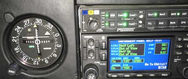
In addition to checking the date of the database and making sure that any waypoints on your route still exist, it is important to pay attention the startup screen. Note how the vertical bar (LCDI) is not half-left. In this case it was due to a failed indicator, but it could also be due to a problem with the receiver.
1−1−17. 3. Oceanic, Domestic, En Route, and Terminal Area Operations
(b) Conduct GPS domestic, en route, and terminal IFR operations only when approved avionics systems are installed. Pilots may use either un-augmented GPS or GPS/WAAS.
(2) Ground−based navigation equipment is not required to be installed and operating for en route IFR operations when using GPS/WAAS navigation systems. All operators should ensure that an alternate means of navigation is available in the unlikely event the GPS/WAAS navigation system becomes inoperative.
(3) Q-routes and T-routes outside Alaska. Q-routes require system performance currently met by GPS, GPS/WAAS… T-routes require GPS or GPS/WAAS equipment.
Note: Q-routes (high) are available for use by RNAV equipped aircraft between 18,000 feet MSL and FL 450 inclusive. Q-routes are depicted on Enroute High Altitude Charts.
T-routes (low) are available for use by RNAV equipped aircraft from 1,200 feet above the surface (or in some instances higher) up to but not including 18,000 feet MSL. T-routes are depicted on Enroute Low Altitude Charts
IFR Approach and Departure
(c) GPS IFR approach/departure operations can be conducted when approved avionics systems are installed and the following requirements are met:
(1) The aircraft is [GPS/WAAS certified]… and
(2) The approach/departure must be retrievable from the current airborne navigation database in the navigation computer. The system must be able to retrieve the procedure by name from the aircraft navigation database. Manual entry of waypoints using latitude/longitude or place/bearing is not permitted for approach procedure.
Departures and Instrument Departure Procedures (DPs)
The GPS receiver must be set to terminal (±1 NM) CDI sensitivity and the navigation routes contained in the database in order to fly published IFR charted departures and DPs. …Certain segments of a DP may require some manual intervention by the pilot, especially when radar vectored to a course or required to intercept a specific course to a waypoint.
GPS Instrument Approach Procedures
(a) GPS overlay approaches are designated non−precision instrument approach procedures that pilots are authorized to fly using GPS avionics. Overlay procedures are identified by the “name of the procedure” and “or GPS” (e.g., VOR/DME or GPS RWY 15) in the title.
(b) Stand−alone approach procedures specifically designed for GPS systems have replaced many of the original overlay approaches. All approaches that contain “GPS” in the title (e.g., “VOR or GPS RWY 24,” “GPS RWY 24,” or “RNAV (GPS) RWY 24”) can be flown using GPS. GPS−equipped aircraft do not need underlying ground−based NAVAIDs or associated aircraft avionics to fly the approach. Monitoring the underlying approach with ground−based NAVAIDs is suggested when able.
[Non-WAAS equipped] may file based on a GPS−based IAP at either the destination or the alternate airport, but not at both locations.
At the alternate airport, pilots may plan for:
(1) Lateral navigation (LNAV) or circling minimum descent altitude (MDA);
The AFM Supplement for the Garmin GNS430 WAAS reinforces this:
It is not acceptable to flight plan a required alternate airport based on RNAV(GPS) LP/LPV or LNAV/VNAV approach minimums. The required alternate airport must be flight planned using an LNAV approach minimums or available ground-based approach aid.
The AIM includes more verbiage about alternates using (baro-VNAV) equipment and RNP 0.3 DA on an RNAV (RNP) IAP. You can ignore references like this in the AIM and other FAA documents if you are a Part 91 pilot since you almost certainly do not have the equipment or training required. Most of these approaches also have an AUTHORIZATION REQUIRED note under the minimums.
Baro VNAV
Baro-VNAV is an RNAV system which uses barometric altitude information from the aircraft’s altimeter to compute vertical guidance for the pilot. Most air carrier aircraft are equipped with Baro VNAV as are many of the FMS equipped Corporate aircraft. Very few general aviation piston aircraft have this equipment installed, although it is availalbe on new Cirrus aircraft.
RNAV (RNP) approaches
RNP stands for Required Navigation Performance. RNP defines a navigation standard that the aircraft must remain within 95% of the time and the obstacle protection is based on the particular RNP value. The Garmin GNSS navigation system complies with the equipment requirements of AC 90-105 and meets the equipment performance and functional requirements to conduct RNP terminal departure and arrival procedures and RNP approach procedures without RF (radius to fix) legs.
However, most pilots are not permitted to do RNAV (RNP) approaches since the aircraft requires special equipment, autopilot, and pilot training. With RNP, there is also a leg type that not all RNP capable avionics are capable of performing called the RF leg (Radius to a Fix)—although an update to the Garmin GTN series will allow it. It is a curved path from one waypoint to another along a constant radius of an arc where the centerpoint of the radius is established at a point off to the inside of the arc.
(e) Procedures for Accomplishing GPS Approaches
1) An RNAV (GPS) procedure may be associated with a Terminal Arrival Area (TAA). The basic design of the RNAV procedure is the “T” design or a modification of the “T”…
(2) Pilots cleared by ATC for an RNAV (GPS) approach should fly the full approach from an Initial Approach Waypoint (IAWP) or feeder fix. Randomly joining an approach at an intermediate fix does not assure terrain clearance.
(3)…Feeder route obstacle clearance is predicated on the receiver being in terminal (±1 NM) CDI sensitivity and RAIM within 30 NM of the airport/heliport reference point; therefore, the receiver should always be armed (if required) not later than the 30 NM annunciation.
(5) …Beginning 2 NM prior to the FAWP, the full scale CDI sensitivity will smoothly change from ±1 NM to ±0.3 NM at the FAWP.…
8) Do not attempt to fly an approach unless the procedure in the onboard database is current and identified as “GPS” on the approach chart.…
(i) Waypoints
(1) GPS receivers navigate from one defined point to another retrieved from the aircraft’s onboard navigational database. These points are waypoints (5-letter pronounceable name), existing VHF intersections, DME fixes with 5−letter pronounceable names and 3-letter NAVAID IDs. Each waypoint is a geographical location defined by a latitude/longitude geographic coordinate. These 5−letter waypoints, VHF intersections, 5−letter pronounceable DME fixes and 3−letter NAVAID IDs are published on various FAA aeronautical navigation products (IFR Enroute Charts, VFR Charts, Terminal Procedures Publications, etc.).
(2) A Computer Navigation Fix (CNF) is also a point defined by a latitude/longitude coordinate and is required to support Performance−Based Navigation (PBN) operations. The GPS receiver uses CNFs in conjunction with waypoints to navigate from point to point. However, CNFs are not recognized by ATC. … CNFs that do appear on aeronautical charts allow pilots increased situational awareness by identifying points in the aircraft database route of flight with points on the aeronautical chart. CNFs are random five-letter identifiers, not pronounceable like waypoints and placed in parenthesis. Eventually, all CNFs will begin with the letters “CF” followed by three consonants (for example, CFWBG).
(3) GPS approaches use fly−over and fly−by waypoints to join route segments on an approach. Fly−by waypoints connect the two segments by allowing the aircraft to turn prior to the current waypoint in order to roll out on course to the next waypoint. This is known as turn anticipation and is compensated for in the airspace and terrain clearances. The MAWP and the missed approach holding waypoint (MAHWP) are normally the only two waypoints on the approach that are not fly−by waypoints. Fly−over waypoints are used when the aircraft must overfly the waypoint prior to starting a turn to the new course. The symbol for a fly-over waypoint is a circled waypoint. Some waypoints may have dual use; for example, as a fly−by waypoint when used as an IF for a NoPT route and as a fly-over waypoint when the same waypoint is also used as an IAF/IF hold-in-lieu of PT. When this occurs, the less restrictive (fly-by) symbology will be charted. Overlay approach charts and some early stand−alone GPS approach charts may not reflect this convention.
(5) The runway threshold waypoint, normally the MAWP, may have a five−letter identifier (for example, SNEEZ) or be coded as RW## (for example, RW36, RW36L). MAWPs located at the runway threshold are being changed to the RW## identifier, while MAWPs not located at the threshold will have a five−letter identifier.